


TREKKING, ESCURSIONISMO, SCIALPINISMO
To the "Vetta della Croce"
To the "Vetta della Croce"
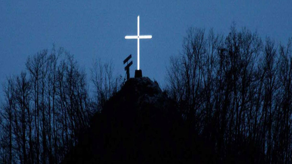
A cross stands at the top of a steep hill to the south of Bagno di Romagna overlooking the town, one of the many crosses that were set up to sanctify the land. It is most noticeable at night when illuminated and has a reassuring effect on the onlooker. The hilltop on which it stands is known as the "Vetta della Croce" (Hilltop of the cross) (763 asl). From here a picturesque panoramic view can be enjoyed which certainly more than repays the modest effort required to make the climb. Following the provincial road SP. 138 from Bagno southward we come to a fork after 1 km and take the right branch, the SP.142 (formerly the SS.71) which leads up to the Mandrioli Pass. After about 400 m, where the road makes a sharp turn to the left across the Becca River, we leave it precisely at the right shoulder of the Beacca bridge (533 asl) to enter the CAI 185A path which immediately starts to climb (ignore the other path - the CAI 185 – which instead descends).
We follow an old mule track, signposted blue/red, which with fast climbs through the copse takes us immediately to the hillside and soon arrives alongside Campitello (585 asl), a large old house surrounded by briars that was abandoned in the mid-sixties. It seems almost suspended on the left side of the Becca Valley toward which stables and a manure pit were oriented. In this derelict agglomeration one can just make out the canopy that once covered the oven and protected the entrance to the kitchen in which a chimney now seems to float in space. The clear mule track, supported continuously by low stone walls on the downhill side, proceeds with pleasant ups and downs into plantations of pines and firs intermingled with hop hornbeams and oaks and then becomes a narrow trail which climbs and follows the Becca River which can be seen further down. At the side of the trail and in the dense wood, where chestnut trees can be glimpsed, the land is sprinkled with squarish blocks that have slipped down from the cliff face, which consists of layers of marl and sandstone like the entire area, and which can be seen protruding here and there above the dense vegetation. Following the blue/red signposts the trail leads us under the canopy of a dense plantation of Austrian pine and emerges into a grassy glade, then after a short descent it starts to climb again toward the ridge above, the presence of which can already be sensed. Glancing to the left through gaps in the vegetation it is possible to see the main ridge of the Apennines and the Mandrioli Pass. The climb continues to a saddle (743 asl) between the steep hillock on the left (859 asl) and the Vetta della Croce on the right (763 asl), on the watershed between the Becca and Volanello valleys. This scene immediately catches the eye with its intense green, the scattered houses, and the Chiardovo trail. Bagno di Romagna, which here is a little concealed from view, becomes easier and easier to see as we continue toward the cross standing on the right and overlooking the town from time immemorial. Two plaques on the base commemorate some works by the population, one in 1998 when a metal cross 7 m high was placed here to replace the previous wooden cross and another in 2010 with the installation of a small solar powered system to illuminate the cross. The landscape that opens up is worth a pause. The details of the town at the bottom of the valley can be seen and further on, along the Savio River, a glimpse of San Piero at the foot of the Corzano hills with the ruins of the medieval castle can be caught. Then there is Montegranelli and also Monte Mescolino which accompany the Savio River toward the plain of Romagna. While behind us toward the south the upper valley narrows, the steep descent toward Bagno starts on the left a few metres after the cross. A great deal of care must be taken as the first 30 m of the CAI 185 trail becomes narrow and steep and the blue/red signposts amid the vegetation are hard to see. Then in the descent toward Rapino the trail widens and becomes clear. Toward the end of the descent majestic old chestnut trees can be seen amid the vegetation, abandoned for some time, in the grip of large leafy vines of ivy. Leaving behind the chestnuts, the trail continues through a fir wood and then passes alongside the piadina kiosk called "Chiosco degli gnomi" at the southern entrance to Bagno di Romagna.
Attention!: As the descent from the Vetta della Croce to Bagno di Romagna is dangerous, it is highly recommended to return to Bagno following the path back to Ponte di Becca.
Warning! Because of the bad weather of the last winter and spring season, along mule tracks and paths you can find trees and signs fallen on the ground, therefore we strongly advise and with care, where the tracing or conventional signs are no longer visible or not explanatory, to adopt the utmost caution and above all to interrupt the chosen ring by retracing the steps already taken backwards.
PATH: Bagno di Romagna - Campitello - Vetta della Croce - Bagno di Romagna. LENGTH: km 5,00 - TIME TRAVELLING: 3 h.
DETAIL: Bagno - Bivio Mandrioli: 1 km / Bivio Mandrioli - Ponte Becca: km 0,400 km / Ponte Becca - Campitello: km 0,400 km / Campitello - Vetta della Croce: 1, 600 km / Vetta della Croce - Bagno: 1,600 km.


 Facebook
 Instagram
 Youtube