


TREKKING, ESCURSIONISMO, SCIALPINISMO
The Gualchiere ring trail
The Gualchiere ring trail
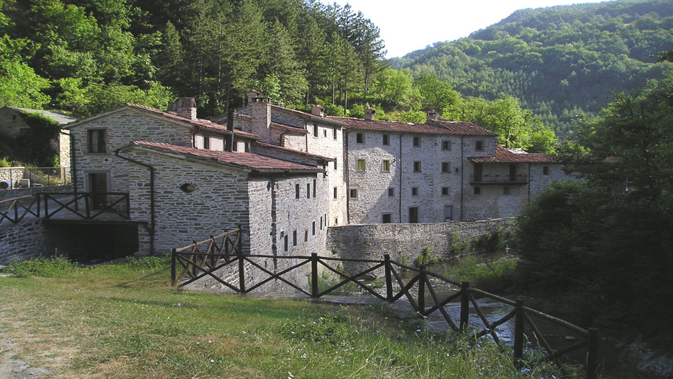
Here is a trail packed with grandeur and landscapes. In one stretch it retraces a via peregrinorum, a route followed by medieval pilgrims from northern Europe to cross the Apennines and go to Rome, known as the “Via Romea di Stade” (The Pilgrim’s Way from Stade to Rome). From Bagno di Romagna we set off southward on the provincial road SP. 138 for just under 1 km and then, at the fork for the "Strada dei Mandrioli" (Mandrioli Road) which proceeds on the right, we take the left branch to the wide SP. 137 for another 200 m as far as a lay-by where our trail starts on the right, next to the shoulder of the bridge over the Gualchiere River. The trail is signposted CAI 177 and 181, Val di Bagno Trek, Il Cammino di San Vicinio, Via Romea di Stade. The trail drops down the narrow valley and crosses the village of Gualchiere (520 asl), an early industrial settlement chronicled since the fifteen hundreds and perfectly restored. The unmade narrow road follows the river course punctuated with small waterfalls. Alongside a trellis the trail climbs on the right to a small clearing where there are well paved stretches of the old mule track. We soon come to the confluence of two rivers that merge and form the Gualchiere River. We cross the single span stone bridge over the Capanno River. Immediately after, just above the Balassini votive shrine to the Madonna, we follow the CAI 177 trail which retraces the medieval pilgrim’s way and zig-zags quickly up the steep secondary ridge that rises between the valleys cut into the land by the Capanno and Chiuso rivers (on the right and left respectively). The mule track – once paved and for the entire Eighteen hundreds the only connection between this part of Romagna and Tuscany – climbs through sparse low vegetation making use of natural steps on the layers of marl and sandstone. The landscape opens up as we pass along the edge of the Capanno River wilderness area, enclosed by the slope we are climbing and the other slope where the hairpins of the SP. 142 wind their way toward the Mandrioli Pass. After bypassing the top of Poggio Alto, the mule track levels out into the broad Nasseto plateau, overlooked by the tall green rock face of the main Apennine ridge. Next to the ruins of the abandoned Nasseto farm (895 asl) – from which an ‘open shelter’ has been made - we take a splendid old road lined with field maple trees, oaks and European hornbeams and cross the extensive undulating meadow sloping down toward the Capanno River. A little further on we come to the fork of the CAI 177 trail, which continues toward the Serra Pass on the Apennine ridge between Romagna and Tuscany, and the CAI 181 which we follow on the left. Flanking an arid crag, the trail runs alongside the pasture and then descends to the head of the little Chiuso valley and fords the river of the same name. Then it climbs the secondary ridge that separates the little valley we are passing through from the Manenti valley, where an optional small detour on the right takes us to the Castel dell'Alpe farm. This farm took its name from the ancient Castrum Alpium standing on the spur overlooking what remains of the farmstead that was abandoned in 1970.
Then, instead of going down to Castel dell'Alpe, continue on the left, always walking on the the undulating ridge, sometimes covered with sparse vegetation, with views over the craggy Chiuso valley covered with extensive clearings and brilliant patches of marl. The trail then proceeds along the steep and completely reforested slope of Monte Valsezza (or Monte Stangone) to a ruin on the hillside, suspended over the narrowing valley. This is the Chiuso (727 asl) and it was also abandoned in 1970. An inscription on the dark rough hewn stone of the fireplace reads "1937". Now we descend through plantations of various types to a place just above where the river flows, following it and then fording to the other side, the left side watershed. Shortly after the mule track comes out next to the Balassini votive shrine to the Madonna just above the bridge over the Capanno River. We resume the trail on the right toward Gualchiere. In the summer it is more enjoyable to follow the riverbed crossing it a number of times.
Warning! Because of the bad weather of the last winter and spring season, along mule tracks and paths you can find trees and signs fallen on the ground, therefore we strongly advise and with care, where the tracing or conventional signs are no longer visible or not explanatory, to adopt the utmost caution and above all to interrupt the chosen ring by retracing the steps already taken backwards.
Gualchiere(518) - Poggio Alto(850) - Nasseto(896) - Passo Serra (1149). From Bagno take southward the prov road 138; 200 m after the crossing with the national road 71, take the dirt road leading to Gualchiere. This trip is not advised in case of snow or rain. Pay attention to grazind herds in the Nasseto plan and,near it, to a schist slippery ground.
Partendo da Bagno di Romagna, occorre seguire in direzione sud la SP. 138 e poi la SP. 137, fino a giungere (1 km circa) ad un piazzale di lato alla strada, ove sulla destra inizia il percorso. Sconsigliato con neve e pioggia. Mandrie al pascolo nella piana di Nasseto. Fare attenzione nel superare il tratto galestroso poco oltre la piana di Nasseto. Si consigliano scarponi, telo e borraccia.


 Facebook
 Instagram
 Youtube