


TREKKING, ESCURSIONISMO, SCIALPINISMO
The Lama ring trail
The Lama ring trail
This excursion is demanding as much as it is picturesque. It passes almost entirely through the finest unspoilt region of the municipal area of Bagno di Romagna that forms a part of the Parco Nazionale delle Foreste Casentinesi. It goes through the very essence of the Park, unforgettable for the beauty of the places visited, the picturesque scenes and atmospheres of the forest and the deafening silences broken only by echoes or the roar of falling water.
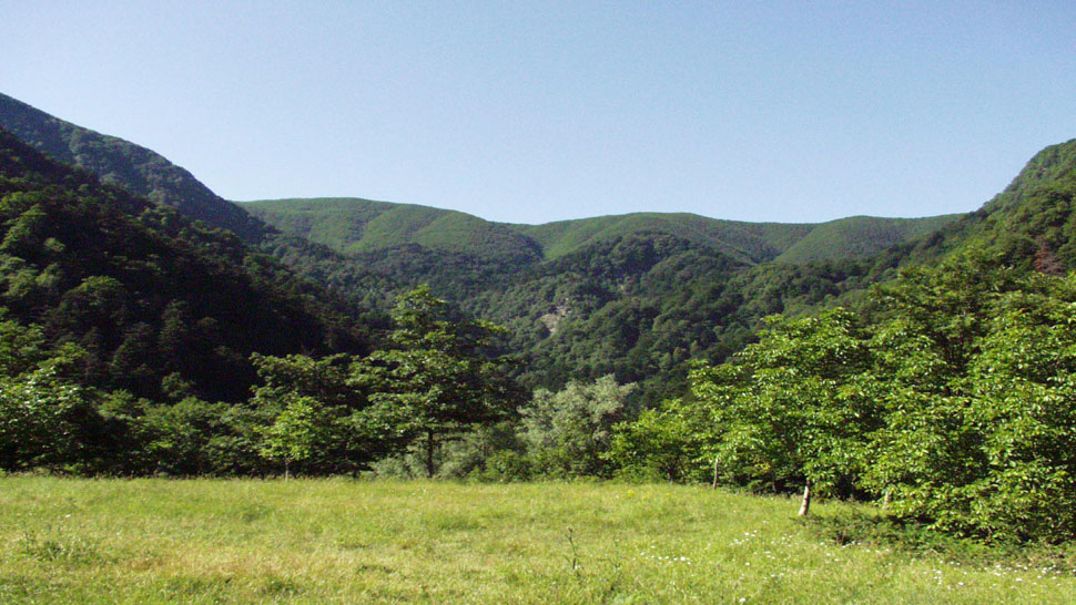
From Bagno di Romagna we first have to drive to Badia Prataglia (16 km) following the spectacular “Strada dei Mandrioli” (Mandrioli Road) (SP. 142 in Romagna, SR. 71 in Tuscany). On reaching the town of Badia Prataglia we leave the SR. 71, which continues down toward Bibbiena, and turn right into the SP. 69 which, after the public gardens, climbs fairly steeply toward the Eremo di Camaldoli (Hermitage of Camaldoli). This road eventually becomes unmade as it nears Aia di Guerrino (km 4.200), very near to the CAI forest shelter of Fangacci (1234 asl) next to Fonte di Guido and a lay-by where we leave the car. Our route starts from here. Ignoring the signs of the various trails, we follow the wide unmade road, now on the level, for about 2 km toward the hermitage and as far as the small parking area of Prato alla Penna (1248 m asl), after passing by a spectacular panoramic view point on the side of Romagna and the lake of Ridracoli. From the parking area we pass a bar and set off on a wide trail along the ridge between Romagna and Tuscany (CAI 00/GEA) enveloped in a dense beechwood. After slightly less than 1 km, at Gioghetto (1239 asl), we leave this trail where it meets another trail on the left that leads to the hermitage below (signposted 70), while we take a wide unmade forestry service road on the right closed with a bar gate. This road is also known as the Acuti road and is marked with signs for the Lama and also signposted 229. It drops down onto the wild Romagna side, through mature beechwoods interspersed with fir woods. A little further on after crossing the Acuti River, which gives the valley its shape, we turn sharply right (1169 asl) to follow the course of river again. The forest all around us becomes increasingly majestic and beautiful. The road, which still has good paved sections, used to be one of the arduous "vie dei legni" (woodsman’s roads) along which oxen, mules and workhorse dragged trunks and long beeches which were then floated down the River Arno to Florence and Pisa. We continue to descend until we come to the Acuti River again, especially charming in spring when full of water. Then we cross it again and follow its course for a long straight stretch until the road turns left and leaves the river for a few hundred metres. From here, looking upward - but only when the trees are bare - we can admire a view of the Scalandrini waterfall where the Fangacci River falls about ninety metres. Continuing downward we come again to the Acuti River which merges with the Fangacci River to form the Lama River that accompanies us all the way down to the plateau of the same name in the heart of the park. The Lama is a meadow (699 m) overlooked by Monte Penna (1333 m) from which the massif of the Apennines between Tuscany and Romagna slopes down creating a landscape of rugged woods, ravines and cliffs in contrast with the gentleness of the little upland where the Lama and Forconali rivers become calmer and merge on their way toward the Lake of Ridracoli. It is one of the most extensive wetlands of the park with ancient marshy depressions now inhabited by patches of alder, poplar and willow. At the edges of this upland located at the centre of a marvellous forest there is a forestry station where visitors can also admire exotic plants of exceptional size, as well as an unusual hawthorn which is about 300 years old. A little further on some gigantic sequoias can be seen. They are absolutely atypical of our region and were planted by the Bohemian Carlo Siemoni who managed the forest for the Grand Duke of Lorena. From a hill next to a little church it is possible to make out the Ridracoli Dam which has modified the landscape with a natural feature in the form of a neck of the lake which has crept as far as the forest creating one of the most picturesque sights of the Apennines. The route continues retracing trail 229 to the signpost of the 227 which indicates the "Sentiero degli Scalandrini" (Scalandrini Trail) on the left. Rather sharp and very hard going, it climbs through very tight hairpins and ramps up a narrow gully at the end of which the Fangacci River passes through enormous rocky masses and trees. It is a fairytale landscape. A little further on, when we go up some rock steps (hence the term scalandrini, a rustic word for steps) with the help of a handrail anchored to the rock face, at the bottom of which there is a waterfall, it really gives the impression of being at Rivendell in The Lord of the Rings! A little further on we come to a sheltered terrace offering a magnificent view of the forest below, the Lama plateau and the Lake of Ridracoli in the distance. The trail now continues a little more easily above the Fangacci River. In the spring or after a storm the roar of the Scalandrini waterfall can be heard here. The waterfall can be reached by making a detour to the right and descending, not without some risk, on a difficult trail that is hard to distinguish. The climb continues more steeply. After crossing a little bridge over the Fangacci River, the trail rises again into the forest and the valley opens up. Finally the Rifugio dei Fangacci (Fangacci Shelter) appears on the left, which was our point of departure. Nearby there is a fountain.
Warning! Because of the bad weather of the last winter and spring season, along mule tracks and paths you can find trees and signs fallen on the ground, therefore we strongly advise and with care, where the tracing or conventional signs are no longer visible or not explanatory, to adopt the utmost caution and above all to interrupt the chosen ring by retracing the steps already taken backwards.
PERCORSO: Passo Fangacci - Prato alla Penna - Acuti - La Lama - Scalandrini - Passo Fangacci. LUNGEZZA: 12,300 km - TEMPO DI PERCORRENZA: 5 ore. - DETTAGLIO: In macchina: Bagno - Badia Prataglia - Rifugio Cai: km 20,200. A piedi: Rifugio CAI - Prato alla Penna: km 2 / Prato alla Penna – Gioghetto: km 0,800 / Gioghetto - Lama: km 5,30 / Lama - Fangacci: km 4, 200.


 Facebook
 Instagram
 Youtube