


TREKKING, ESCURSIONISMO, SCIALPINISMO
L'anello dei Mandrioli
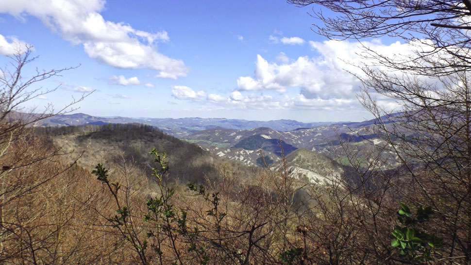
The Mandrioli ring trail
This is the longest and most challenging of the routes suggested, but it passes through a landscape of great beauty and historical points of interest. It starts from the old fulling mill (Gualchiere) south of Bagno, along the provincial road SP. 137 which leads to Verghereto, from the left shoulder of a bridge. It is signposted blue/red CAI 177 and 181, Val di Bagno Trek, Cammino di San Vicinio. We go down the narrow valley and pass through the village of the old mill (Gualchiere) (510 asl). The road runs along the river then – alongside a trellis – it climbs on the right through a small wood with paved sections and soon comes to the confluence of the streams that give rise to the river of Gualchiere. Then we cross a stone bridge over the Capanno River. Immediately after, just above the Balassini votive shrine to the Madonna, the 181 trail forks left but we take the right branch, the CAI 177 which follows the route of the medieval pilgrims and zig-zags quickly up the steep secondary ridge between the Capanno and Chiuso valleys (on the right and left respectively). We climb through sparse vegetation on natural steps and strata of marl and sandstone. The landscape opens up and we walk along the edge of the Capanno River wilderness area, enclosed between the side we are climbing and the other side up which the Mandrioli Road winds its way (SP.142). After bypassing the top of Poggio Alto, the mule track levels out into a plateau (899 asl) overlooked by the Apennine ridge. Next to the ruins of the Nasseto farm – which has been made into an ‘open shelter’ – we push on along a magnificent maple-lined road which indicates the way. A little further on we come to the fork with the CAI 181 trail which drops down on the left toward the river, while our trail CAI 177 proceeds along the arid hillside of slippery marl and then enters the beechwood that covers the slopes of Monte Zuccherodante. After many hairpin bends we finally emerge at the Serra Pass (1150 asl), where a memorial stone reminds us that the medieval pilgrims’ route to Rome crossed the mountains between Romagna and Tuscany at this point. We continue down the mule track for 200 m and crossing a clearing, in summer covered with ferns, we come to a junction with numerous signs (1102 asl). We take the 00/GEA/GAVB, toward the right following a wide track that skirts Monte Zuccherodante and follows the watershed ridge through tall trees. Ignoring the turnoffs on the left, we reach the Mandrioli Pass (1173 asl) and come out at the former SS. 71, now renamed SP. 142. After enjoying the superb panorama that opens up toward Romagna we continue on the left along the provincial road on the Tuscany side (SR. 71) for about 400 m. After passing a hut, we cross the asphalt at a tight bend to pick up the CAI 00 trail (1160 asl) on the right which immediately climbs into a beechwood with about 500 m of hard going uphill at the end of which a clearing slopes down toward the Casentino valley and we arrive at Poggio Lombardona (1265 asl), indicated by a stud by the military geographical institute (IGM, Istituto Geografico Militare). At this point the 00 winds along the imposing ridge on the eastern boundary of the National Park, running along the edge of a spectacular precipice overlooking the “Mandrioli Road" and the entire Savio Valley. We pass by Cima Termine (1277 asl) and about half a kilometre further on we leave the 00, which turns abruptly left, and take the CAI 201/ VDBT on the right which drops steeply 700 m to Prato dei Grilli and enters a forest track (1019 asl). We continue on the left and soon (300 m) come to a bar gate where we take the CAI 185 on the right which drops into the Becca Valley. With fast hairpin bends the mule track cuts diagonally across the hillside, frequently disappearing into the woods. Towards the valley bottom a glimpse can be caught of the ruins of the Serciole, Casanova and Campo del Rosso farms and then we pass by the ruined Becca hut (772 asl). Here the partly paved mule track descends with tight hairpins into the dense vegetation. Then we come to two votive shrines to the Madonna, one after the other, of which the second is at the edge of a picnic area. In less than 1 km a forest track running alongside the river meets the provincial road SP. 142. Here we turn left and continue to the fork with the SP. 137, where we turn off to the right and shortly after reach the point of departure.
Warning! Because of the bad weather of the last winter and spring season, along mule tracks and paths you can find trees and signs fallen on the ground, therefore we strongly advise and with care, where the tracing or conventional signs are no longer visible or not explanatory, to adopt the utmost caution and above all to interrupt the chosen ring by retracing the steps already taken backwards.
PATH: Gualchiere - Passo Serra - Passo Mandrioli - Cima Termine - Prato dei Grilli - Valle di Becca - Gualchiere. LENGTH: km 18,00 - TIME TRAVELLING: 6 hours.
DETAIL: Gualchiere - Passo Serra: km 5,00 / Passo Serra - Bivio GEA: km 0, 200 / Bivio Gea - Mandrioli: km 3,400 / Mandrioli - Cima Termine: km. 2,800 / Cima Termine - Prato dei Grilli: km 1,200 / Prato dei Grilli - imbocco Becca: km 0,300 / Imbocco Becca - SP 142: km 3,500 / SP 142 - Gualchiere. km 0,600.


 Facebook
 Instagram
 Youtube